
Mine Lease Deformation Baseline Assessment
12-Month Sentinel-1 SBAS InSAR Monitoring over an Active Open-Cast Mining Operation
Executive Summary
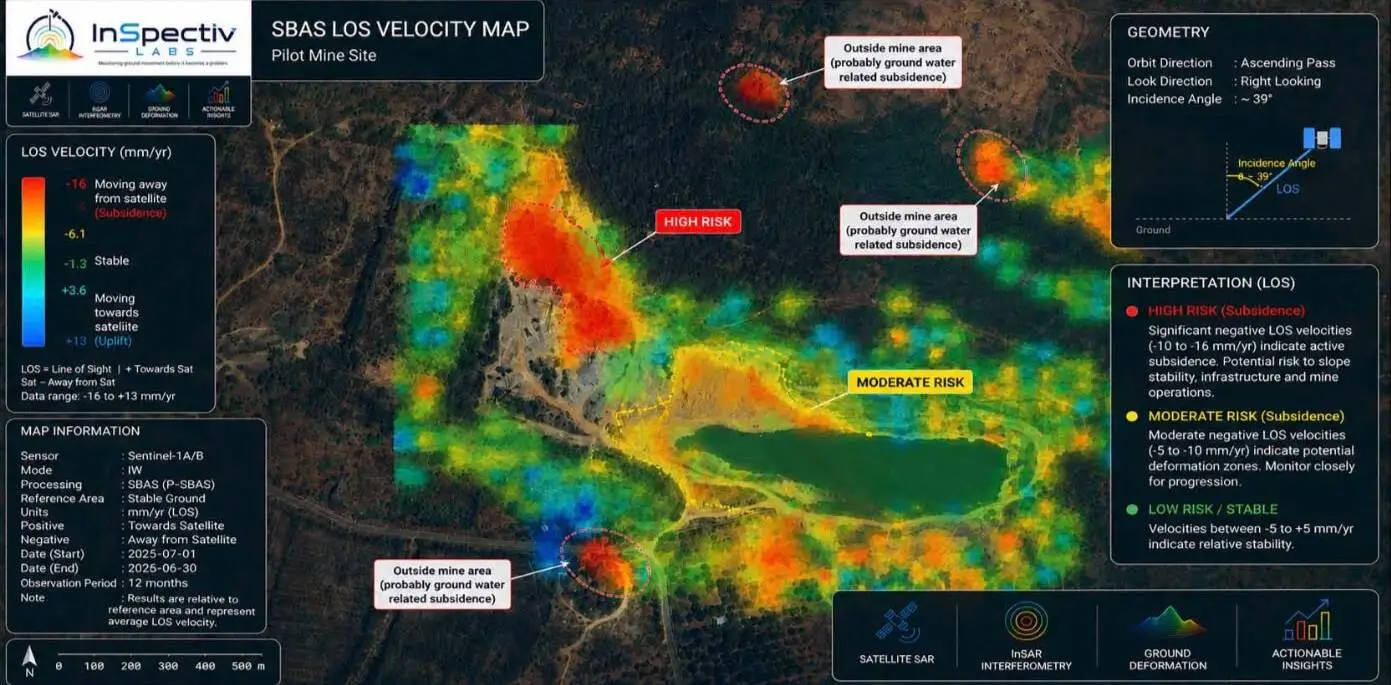
InSpectiv Labs completed a 12-month satellite-based ground deformation assessment over an active open-cast mining lease using Sentinel-1 SAR data processed with the SBAS InSAR technique. The assessment mapped overall lease stability, successfully pinpointed localized subsidence zones (-10 to -16 mm/yr) adjacent to active excavation, and differentiated mine-induced movement from off-site groundwater fluctuations.
The Challenge
Open-cast mining continuously modifies slope geometry, bench configurations, and localized hydrogeology. These operational changes induce gradual ground shifts long before visible cracks appear. Mine operators require continuous, lease-wide deformation screening without incurring the extreme capital expenditure of dense ground-based hardware sensor networks.
InSpectiv Labs Solution & Methodology
Data Engine
Processing Technique
Measurement Physics
Analytical Focus
Key Technical Findings
| Zone Classification | Observed Satellite Signal | Geotechnical Interpretation & Action |
|---|---|---|
| High-Risk Zone | -10 to -16 mm/yr | Active subsidence adjacent to active excavation. Immediate field verification and close monitoring required. |
| Moderate-Risk Zone | -5 to -10 mm/yr | Potential slope/ground settlement. Recommended for ongoing trend tracking across future observation cycles. |
| General Mine Lease | -5 to +13 mm/yr | Stable ground. No evidence of widespread or accelerating structural deformation detected. |
| Off-Site Anomalies | Localized Red Patches | Subsidence detected outside lease boundary; attributed to groundwater/seasonal moisture shifts, not mining activity. |
Business Impact
Cost-Effective Screening
Evaluates multi-square-kilometer lease areas remotely, flagging risk zones for targeted engineering checks.
Anomaly Discrimination
Clear spatial delineation protects operators by distinguishing off-lease environmental shifts from mine-induced ground movements.
Proactive Risk Management
Enables integration of satellite radar insights into geotechnical planning, bench design, and site safety protocols.
Want similar insights for your assets?
Connect with our geotechnical monitoring experts to discuss your requirements.
Contact Us